


Modern unmanned aerial vehicle (UAV) operations strive for maximum automation. This reduces operator workload and enhances mission precision. In autonomous flight modes, the UAV assumes full navigation responsibility, allowing the pilot to focus entirely on situational awareness and intelligence analysis. At the core of autonomous flight lie two fundamentally distinct methodologies: Area Flight Planning and Waypoint Navigation.
The lineage of these technologies traces back to commercial engineering. Today, the technological foundation originally developed for precision agriculture serves as the backbone for highly resilient military UAV platforms, such as the KAZHAN (BAT) heavy strike-reconnaissance system and the SHMAVIK compact reconnaissance drone.
1. Area Flight Planning: Continuous Territorial Coverage
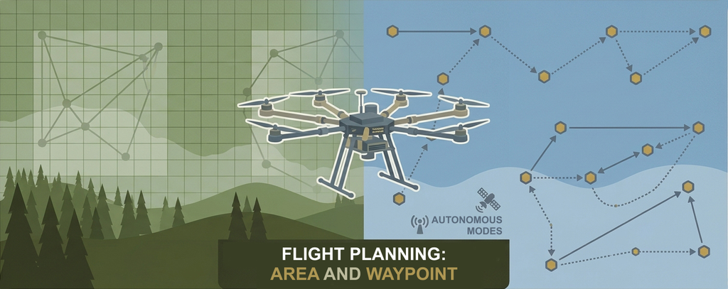
The area flight mode was designed for tasks requiring systematic and uniform coverage of a designated sector.
How It Works: The operator selects a target polygon on the ground control station (GCS) map. The planning software automatically calculates a lawnmower flight pattern (parallel sweeps) to cover the entire area based on the drone’s sensor specifications and field of view. In agricultural applications (e.g., spraying drones), pass spacing is calculated at precise 10-meter intervals corresponding to the spray swath width.
Autonomous Intelligence: The flight controller logs the exact coordinates when battery voltage drops or payload capacity is exhausted. The UAV automatically initiates a Return to Launch (RTL) routine for servicing (battery hot-swap or payload reload). Upon re-deployment, the platform autonomously navigates back to the exact interruption coordinate and seamlessly resumes the survey sweep.
In a tactical context, area mapping is essential for generating high-resolution orthomosaics, 3D terrain modeling, and wide-area baseline reconnaissance.
2. Waypoint Navigation: Flexible Tactical Planning
While area planning focuses on continuous spatial coverage, waypoint navigation delivers pinpoint precision and tactical adaptability—making it the primary operational mode in contested combat environments.
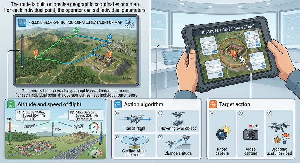
How It Works: Flight paths are plotted using precise geographical coordinates or via an interactive GCS map layer. The operator configures individual flight parameters for each discrete waypoint:
– Transit altitude and airspeed;
– Specific flight behavior: direct transit, stationary hovering, orbit around a target at a designated radius, or altitude transition;
– Target actions: triggering photo/video capture, activating payload release mechanisms.
During route generation, the flight management software continuously computes inter-waypoint distances, total track length, and required energy reserves. Throughout the mission, real-time status telemetry informs the operator of mission progress, completed waypoints, and subsystem health.
In-Flight Adaptability: Waypoint execution can be paused at any moment to divert for real-time target re-acquisition or execute an immediate Return to Base (RTB). The flight controller stores the divert coordinate, allowing the aircraft to rapidly rejoin its original flight plan.
Strategic Value in Modern Warfare
In today’s combat environment, where every flight faces intense EW threat, manual control is most commonly used. However, relying on waypoints is pretty much the limit of what we can achieve in the vast majority of cases and for most missions:
1. Covert Reconnaissance & Fire Adjustment:
The SHMAVIK reconnaissance drone leverages waypoint navigation to execute low-altitude ingress along complex, low-observable terrain-masking routes—effectively bypassing known air defense and EW threat sectors.
2. Precision Payload Delivery & Tactical Logistics:
The KAZHAN 630 heavy hexacopter and KAZHAN 620 quadcopter perform automated day and night waypoint sorties to deliver heavy munitions or critical supplies into high-risk kill zones with extreme accuracy, where a few meters of course deviation could prove fatal.
3. Operator Workload Mitigation:
With stable satellite positioning (GNSS), the onboard avionics execute all complex flight maneuvers autonomously. The operator is freed to concentrate on analyzing live ISR video feeds and monitoring critical mission metrics.
The integration of flexible waypoint planning software with hardened, cryptographically secure hardware transforms KAZHAN and SHMAVIK platforms into reliable, force-multiplying tools for execution of high-risk autonomous missions.